
Lake News Alerts
We'd like to send you lake news articles, videos, and podcasts from around the web.
 We will never share your email
|
Missouri River
|
|
Length: 2565 miles (4,128 kilometers)
The Missouri River, approximately 2565 miles long (including its Jefferson-Beaverhead-Red Rock headstream), is the longest river of the United States and is the principal tributary of the Mississippi River. The length of the combined Missouri-Mississippi system from the headwaters of the Missouri to the mouth of the Mississippi is approximately 3,740 miles making it the world’s third longest river after the Nile and the Amazon. The Missouri R. drains an area of approximately 580,000 square miles, including 2,550 square miles in Canada. The principal headwaters of the Missouri are the Jefferson, Madison, and Gallatin rivers, which rise high in the Rocky Mountains, southwest Montana, and join to form the Missouri near Three Forks, Montana. The Missouri’s upper course flows north through scenic mountainous terrain including Gate of the Mountains, a deep gorge. At Great Falls, Montana, the river enters a 10-mile stretch of cataracts that prevented navigation to the upper river and effectively established Fort Benton, Montana, as the head of navigation for 19th-century riverboats. Below Fort Benton, the Missouri follows a meandering course east and then southeast across the Great Plains of west-central United States, crossing Montana, North Dakota., and South Dakota, and forming part of the boundaries of Nebraska, Kansas, and Iowa before crossing Missouri and entering the Mississippi River 17 miles north of St. Louis. Nicknamed “Big Muddy” for its heavy load of silt, the brown waters of the Missouri do not readily mix with the gray waters of the Mississippi until approximately 100 miles downstream. The Yellowstone, Platte, Kansas, and Osage rivers are the Missouri’s chief tributaries. Above Sioux City, Iowa, the Missouri’s fluctuating flow is regulated by seven major dams (Gavins Point, Fort Randall, Big Bend, Oahe, Garrison, Fort Peck, and Canyon Ferry) and more than 80 other dams on tributary streams. These dams, with their reservoirs, are part of the coordinated, basinwide Missouri River basin project (authorized by the Unted States Congress in 1944), which provides for flood control, navigation, hydroelectric power, irrigation water, and recreational facilities. The dams serve to impound for later use the spring rains and snow melt that swell the volume of the river in March and April and also the second flood stage that frequently occurs in June as the snow melts in the more remote mountainous regions. Because the dams have no locks, Sioux City is the head of navigation for the 9-foot channel maintained over the 760-mile stretch downstream to the Mississippi. Tugboats pushing strings of barges move freight along this route. From December to March, navigation is interrupted by ice and low water levels (resulting from upstream freezing); summer water levels, which frequently fall so low as to cause riverboats to go aground, are now maintained at safe levels by the release of water from Gavins Point Dam. Silt, fertilizers, and pesticides, which are contained in the runoff from agricultural lands, and urban areas pollute the river at selected times of the year. The Missouri River was an important artery of commerce for Native American villages of the Plains culture long before the French explorers Jacques Marquette and Louis Joliet passed the mouth of the river in 1683 and the Canadian explorer Vérendrye visited the upper reaches of the river in 1738. David Thompson, a Canadian fur trader, explored part of the river in 1797. Meriwether Lewis and William Clark followed the Missouri on their journey (1803–1806) to the Pacific Ocean and described it at length. The first steamboat ascended the river in 1819 and hundreds more later navigated the uncertain waters to Fort Benton. Mormons bound for Utah and pioneers bound for Oregon and California followed the Missouri valley and that of the Platte overland to the West. River traffic declined with the loss of freight to the railroad after the Civil War, but it has been revitalized in the 20th century, in the section below Sioux City, through the navigational improvements and flood control efforts of the Missouri River basin project. The Missouri River is the water supply for several million people. Occasional high floods cause considerable damage. The Great Flood of 1993 on the river below Omaha, which set record crests and record discharges, and another flood in 1995, have prompted reevaluation of river management, goals, and strategies.
MISSOURI RIVER LAKES
|
|

|
Fort Peck Lake, or Lake Fort Peck, is a major reservoir in Montana, formed by the Fort Peck Dam on the Missouri River. The lake lies in the eastern prairie region of Montana approximately 140 miles east of Great Falls and 120 miles north of Billings, reaching into portions of six counties.
The dam and reservoir were built in response to severe flo...


Full Pool: 2,234.0 MSL
Area: 245,000 Acres
|
|
|
|
|
...
Full Pool: 1,420.0 MSL
Area: 60,000 Acres
|
|
|
|
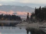
Canyon Ferry Lake is a reservoir on the Missouri River near Helena, Montana and Townsend, Montana. It is Montana's third largest body of water, covering 35,181 acres and 76 miles of shore. It was formed by the building of Canyon Ferry Dam, which was completed in 1954 and has been used for electricity, irrigation, and flood controls since. The lake ...
|
|
|
|
|
Lake Sakakawea is a reservoir in the north central United States, located in the Missouri River basin in central North Dakota....
|
|
|
|
|
...
|
|
|


