
Lake News Alerts
We'd like to send you lake news articles, videos, and podcasts from around the web.
 We will never share your email
|
Ouachita River
|
|
Length: 600 miles (966 kilometers)
(WAHSH-uh-tah), Rises in the Ouachita Mountains in west Arkansas and flows east-southeast and south through the Ouachita Mountains and the cotton-producing region of south Arkansas and northeast Lousiana and into the Red River system. It is joined by the Tensas River at Jonesville, Louisana, to form the Black River. Hot Springs, Arkansas, and Monroe, Louisana, are the largest cities on the river; also important are Arkadelphia and Camden, Arkansa. The river is navigable for shallow-draft vessels below Arkadelphia. Three dams in the river near Hot Springs—Remmel (completed 1925), Carpenter (1931), and Blakeley Mountain (1955)—impound respectively Lake Catherine, Lake Hamilton, and Lake Ouachita (63 square miles - Arkansas' largest). There is a hydroelectric power plant at Blakeley Mountain Dam. Felsenthal Dam in south Arkansas impounds Lake Jack Lee. The lakes, part of a Federal flood-control project, are the center of a popular recreation area.
OUACHITA RIVER LAKES
|
|
|
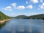
Lake Ouachita (Pronounced WAH-shi-tah) is a reservoir created by the damming of the Ouachita River by Blakely Mountain Dam.
The Downstream side of Blakely Mountain Dam as photographed from the river in July 25, 2009
Blakely Mountain Dam was built by the United States Army Corps of Engineers from 1948 to 1953 for hydroelectric power, recreatio...
|
|
|

|
Lake Catherine was created in a virtual wilderness between Hot Springs and Malvern. Eleven miles long, the lake covers a mere 1,940 acres, nestled in narrow valleys of the Ouachita Mountains....
|
|
|
|
|
Lake Hamilton was created in 1932 when the Arkansas Power and Light Co. completed Carpenter Dam on the Ouachita River to generate electricity. Today, the 7,460-acre impoundment is one of Arkansas's most popular recreational and residential lakes. Much of it is ringed with condominiums, resorts, motels, restaurants and private homes. State Scenic 7 ...
|
|
|
|
|
The Felsenthal Lock and Dam is part of the Ouachita River Basin, which is characterized by hilly wetlands and the 605-mile Ouachita River running through it. Local recreational activities include boating, camping, fishing, hunting, and hiking....
|
|
Outflows of the Ouachita River
|
|
Red River
|
|
|


