
Lake News Alerts
We'd like to send you lake news articles, videos, and podcasts from around the web.
 We will never share your email
|
Colorado River
|
|
Length: 1450 miles (2,333 kilometers)
Colorado River rising in the Rocky Mountains of north Colorado, in northwest Rocky Mountain National Park northwest of Denver, and flowing generally southwest through Colorado, Utah, Arizona, then between Nevada and Arizona, and Arizona and California, and then into Mexico, emptying into the Gulf of California. The Colorado River drains 244,000 square miles. The source is surrounded on three sides by the Continental Divide; flows south through Grand Lake (Shadow Mountain Reservoir) and Lake Granby reservoirs, then generally southwest past Glenwood Springs, Rifle, and Grand Junction, Colorado, where it receives the Gunnison River from southeast, into Utah, where it forms the south boundary of Arches National Park at Moab, then through Canyonlands National Park, where it receives the Green River, its longest tributary from the north. The Colorado then enters Glen Canyon National Recreational Area and Lake Powell, formed by the Glen Canyon Dam at Page, in extreme northeast Arizona, and at 26,997,000,000 cubic feet is the 2d largest reservoir in the United States. The Colorado receives the San Juan River from the east. Below Glen Canyon Dam, the river enters Marble Canyon and Grand Canyon National Park. (The river and part of Lake Powell form the northwest boundary of the Navajo Indian Reservation.) Due to major park expansion in 1975, the river flows 140 miles through the park, through Marble Canyon and the spectacular Grand Canyon; then for another 100 miles it forms the south boundary of the west extension of the park and north boundary of Hualapai Indian Reservation. It then enters Lake Mead National Recreational Area (at 28,253,000,000 cubic feet Lake Mead, formed by Hoover Dam, is the largest reservoir in the United States). The lake and Lake Mohave below it, formed by Davis Dam, form the Arizona-Nevada state line. The large north arm of Lake Mead receives the Virgin River from the northeast. Below the Hoover Dam, the river flows almost due south. Below the Davis Dam, it flows through Fort Mohave Indian Reservation and becomes the California-Arizona state line. It forms the boundary of Havasu National Wildlife Refuge, east, and Chemehueva Indian Reservation, west, flowing past Lake Havasu City and through Lake Havasu, formed by Parker Dam. Below Parker Dam, the river flows past Parker; through Colorado Indian Reservation; through Cibola and Imperial National wildlife refuges; forms east and south boundary of Fort Yuma Indian Reservation; and past Yuma, Arizona. Around Yuma, the Colorado passes through Imperial, Laguna, and Morelos dams, each with minor reservoirs, the volume of the river having been reduced by diversion to major cities and irrigation projects in California, Nevada, and Arizona. Just east of Yuma, the Colorado receives the Gila River from east. Below Yuma, the river forms part of the United States-Mexico border. Approximately final 100 miles of the river, reduced to a braided trickle, flows through Mexico, forming the border between Baja California Norte and Sonora states, and enters the north end of the Gulf of California. In its small delta is Isla Montague. Many national parks, monuments, and recreational areas are located along the river banks. The Colorado’s waters are used for power and irrigation, especially by means of the Colorado River. storage project, the Colorado–Big Thompson project, Hoover Dam, Davis Dam, Imperial Dam, the All-American Canal, Parker Dam, and Glen Canyon Dam. Controversies over water rights on the Colorado have long raged between the United States and Mexico and among the bordering states; treaties and compacts regulate the river’s use.
COLORADO RIVER LAKES
|
|

|
Shadow Mountain Lake is a reservoir in Grand County, Colorado, near the headwaters of the Colorado River. Shadow Mountain Lake is created by Shadow Mountain Dam. The lake forms a continuous body of water with Grand Lake, the largest natural lake in Colorado; they are separated by gates.
Shadow Mountain Lake is part of Arapaho National Recreation...


Full Pool: 8,366.0 MSL
Area: 1,346 Acres
|
|
|
|
|
Lake Granby is the third largest body of water in Colorado.
It was created by the erection of Granby Dam, completed in 1950, as part of the Bureau of Reclamation's Colorado-Big Thompson Project. Water from Lake Granby is pumped via the Farr Pump plant though a pipeline that empties into a canal connected to Shadow Mountain Reservoir. The Bureau ...
Full Pool: 8,284.0 MSL
Area: 7,260 Acres
|
|
|
|
|
Lake Powell is a reservoir on the Colorado River, straddling the border between Utah and Arizona (most of it, along with Rainbow Bridge, is in Utah). It is a major vacation spot that around two million people visit every year. It is the second largest man-made reservoir by maximum water capacity in the United States behind Lake Mead, storing 24,322...
Full Pool: 3,700.0 MSL
Area: 161,390 Acres
|
|
|
|
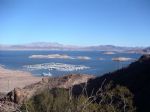
Lake Mead is the largest reservoir in the United States in maximum water capacity. It is located on the Colorado River about 24 mi from the Strip southeast of Las Vegas, Nevada, in the states of Nevada and Arizona. Formed by the Hoover Dam, Lake Mead is 112 miles long when the lake is full, has 759 miles of shoreline, is 532 feet at greatest depth,...
|
|
|
|
|
Lake Mohave is a reservoir formed by Davis Dam on the Colorado River, which defines the border between Nevada and Arizona in the United States. The lake lies at an elevation of 647 feet (197 m) near Laughlin, Nevada, Searchlight, Nevada, Cottonwood Cove, Nevada, and Bullhead City, Arizona, about 67 miles (108 km) downstream from Hoover Dam. The lak...
Full Pool: 647.0 MSL
Area: 26,500 Acres
|
|
|
|
|
Lake Havasu is a large reservoir behind Parker Dam on the Colorado River, on the border between California and Arizona. Lake Havasu City sits on the lake's eastern shore. The lake has a capacity of 648,000 acre feet (799,000,000 m3). The concrete arch dam was built by the United States Bureau of Reclamation between 1934 and 1938. The lake's primary...
Full Pool: 445.0 MSL
Area: 19,300 Acres
|
|
|


