
Lake News Alerts
We'd like to send you lake news articles, videos, and podcasts from around the web.
 We will never share your email
|
Holston River
|
|
Length: 120 miles (193 kilometers)
Holston River, approximately 120 miles long, formed by the uniting of its northern and southern forks, northeast Tennessee, and flowing southeast through the Great Appalachian Valley, joining the French Broad River at Knoxville to form the Tennessee River. Settlement along the Holston began before the American Revolution, and it was a major route of westward migration. On the river is Cherokee Dam, a flood control unit of the Tennessee Valley Authority that impounds Cherokee Lake; there are several smaller dams on the Holston’s southern fork.
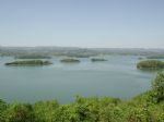
HOLSTON RIVER LAKES
|
|

|
Boone Reservoir features a swimming area above the dam and a boat ramp including a courtesy pier for safe, convenient boat launching and retrieval. Water skiing and fishing are popular pastimes at Boone.
The reservoir is operated for a number of purposes, including power production, flood control, water supply, water quality, and aquatic ecology...


Full Pool: 1,382.0 MSL
Area: 4,510 Acres
|
|
|
|
Water Source - A TVA impoundment of the Holston River constructed in 1943 to provide hydroelectric power, flood control and recreation. Major tributaries include Poor Valley, Ray and German creeks.
Water - Fertile and often stained from muddy runoff, or algae that produces a greenish tint. The thermocline develops in April and is most pronounc...
|
|
|


