
Lake News Alerts
We'd like to send you lake news articles, videos, and podcasts from around the web.
 We will never share your email
|
Coosa River
|
|
Length: 286 miles (460 kilometers)
Coosa (KOO-suh) - Rising in northwest Georgia and flowing southwest through east Alabama, joining the Tallapoosa River near Montgomery, Alabama, to form the Alabama River. Counties the Coosa River borders or flows through: Cherokee, Etowah, Calhoun, St. Clair, Talladega, Shelby, Coosa, Chilton, and Elmore
COOSA RIVER PADDLING COURSES
|
|
|
The Lower Coosa segment, known as Coosa River Whitewater, has turbulent waters and Class III rapids. The fall line, the last stone underlayment supporting the Alabama uplands before the rivers grind deep into the plains on their way to the Gulf of Mexico, is an exciting place on any river in Alabama. It's especially loved on the Coosa River near th...
|
COOSA RIVER LAKES
|
|
|
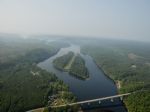
Lake Weiss (pronounced "Wice") is an Alabama Power Company hydroelectric impoundment covering 30,200 acres in northeast Alabama on the Alabama - Georgia border. The Weiss Lake fishery is the major economic influence in Cherokee County, so the locals treat anglers very well. Four free public access areas and 37 privately run marinas service Lake Wei...
|
|
|
|
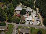
Neely Henry Reservoir is located in northeast Alabama on the Coosa River, near the towns of Gadsden and Ohatchee. Just off I-59, the reservoir envelops 11,235 acres and extends 77.6 miles from the dam upstream to Weiss dam. Generally a river-run lake, Neely Henry fans out toward the dam to offer more open water. Sandwiched between Weiss Lake (a.k.a...
|
|
|

|
Logan Martin Lake is located on the Coosa River in east-central Alabama approximately 30 miles east of Birmingham, Alabama. This 17,000 acre Coosa River reservoir was built in 1965 by Alabama Power Company. Nicknamed "Lake of a Thousand Coves" by locals, Logan Martin has 275 miles of shoreline along its 48.5 mile length sandwiched between Logan Ma...
|
|
|

|
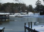
Lay Lake is a 12,000-acre reservoir located thirty-five minutes south of Birmingham off I-65 and fifteen miles south of Columbiana in east-central Alabama. Lay Lake borders St. Clair, Talladega, Shelby, Coosa, and Chilton Counties. The primary uses for this reservoir are hydroelectric generation and recreation. Lay Lake is popular for tournament ...
|
|
|
|
Located just off I-65 and ten miles due east of the city of Clanton in central Alabama, Lake Mitchell is a 5,850-acre impoundment on the Coosa River with 147 miles of shoreline. The Lay Dam tailwater area at the upper end of the lake is a popular recreational area to many anglers with ample bank fishing access. Impounded by Alabama Power in 1922, a...
|
|
|

|
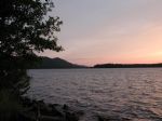
Located twenty-five miles due north of the city of Montgomery in central Alabama, Lake Jordan is a 6,800-acre impoundment on the Coosa River with 188 miles of shoreline. The Mitchell Dam tailwater area at the upper end of the lake is a popular recreational area to many anglers with ample bank fishing access. Lake Jordan was impounded by Alabama Pow...
|
|
|


