
Lake News Alerts
We'd like to send you lake news articles, videos, and podcasts from around the web.
 We will never share your email
|
Little Red River
|
|
Length: 105 miles (169 kilometers)
Located in northwest Arkansas, rising in the Boston Mountains, and flowing southeast to the White River. Archeys Fork (30 mi/48 km long) joins south Fork at Clinton (40 mi/64 km long); both rise in W Van Buren co. Middle Fork (60 mi/97 km long) rises in S Searcy co., and joins South Fork at Edgemont, Cleburne co., in Greers Ferry L. Main river continues another 75 mi/121 km to White R., part Searcy. Greers Ferry Dam and reservoir (completed 1964) provide flood control and hydroelectric power.
LITTLE RED RIVER LAKES
|
|
|
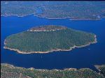
Greers Ferry Lake is the reservoir formed by Greers Ferry Dam, a United States Army Corps of Engineers dam in Northern Arkansas. It is located about 60 miles (100 km) north of Little Rock. It is often ranked as one of the top ten clearest, cleanest, and most pristine lakes in all of North America.
The reservoir consists of two lakes connected by a...
|
|
|


