
Lake News Alerts
We'd like to send you lake news articles, videos, and podcasts from around the web.
 We will never share your email
|
Tennessee River
|
|
Length: 650 miles (1,046 kilometers)
Tennessee River is the principal tributary of the Ohio River, approximately 650 miles long; formed by the confluence of the Holston and French Broad rivers near Knoxville, Tennessee, and follows a U-shaped course to enter the Ohio R. at Paducah, Kentucky. Its drainage basin covers approximately 41,000 square miles and includes parts of seven states. Navigation was long impeded by variations in channel depths and by rapids, such as Muscle Shoals, Alabama. However, the TVA (est. 1933) converted the river into a chain of lakes held back by nine major dams (Kentucky, Pickwick Landing, Wilson, Wheeler, Guntersville, Nickajack, Chickamauga, Watts Bar, and Fort Loudoun). As a result of these improvements, river traffic has increased, flooding has been controlled, a water-oriented recreation industry has been established, and hydroelectric power generated at the dams has attracted new industries to the region. A canal, completed in the 1980s, links the Tennessee River with the Gulf of Mexico by way of the Tombigee River. During the Civil War, the Tennessee River was a prime approach for a Union invasion of the South.
TENNESSEE RIVER LAKES
|
|

|
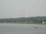
Fort Loudoun Reservoir, located on the Tennessee River at Knoxville, is the uppermost in the chain of nine TVA reservoirs that form a continuous navigable channel from there to Paducah, Kentucky, 652 miles away.
Fort Loudoun Reservoir takes its name from the 18th-century British fort built on a nearby site during the French and Indian War. The f...
|
|
|
|
Located about midway between Chattanooga and Knoxville, the lake begins as the Tennessee River below Fort Loudon Dam in Lenoir City, Tennessee and stretches 72.4 miles (116.5 km) to Watts Bar Dam, near Spring City, Tennessee.
The Clinch River connects to the main channel of the lake at mile 568 near Southwest Point in Kingston, Tennessee. The ...
|
|
|
|
Chickamauga Lake is a reservoir along the Tennessee River created when the Chickamauga Dam, as part of the Tennessee Valley Authority, was completed in 1940. The lake stretches from Watts Bar Dam at mile 529.9 (853 km) to Chickamauga Dam at mile 471.0 (758 km) making the lake 58.9 miles (94.8 km) long. It borders Rhea County, Meigs County, and Hami...
|
|
|
|
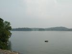
Nickajack Lake is the reservoir created by Nickajack Dam as part of the Tennessee Valley Authority. The lake stretches from Nickajack Dam north to Chickamauga Dam and runs along the shores of Chattanooga, Tennessee. The stretch of the Tennessee River commonly referred to as the "Grand Canyon of Tennessee" also is part of Nickajack Lake.
Full pool ...
|
|
|

|
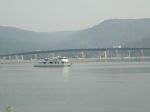
Lake Guntersville is located in north Alabama between Bridgeport and Guntersville. Alabama's largest lake contains 69,100 acres and stretches 75 miles from Nickajack Dam to Guntersville Dam. Free boat ramps and private marinas dot the lake's perimeter. Fishing, boating, camping, hunting and eagle watching are popular sports in the area. Eagle watch...
|
|
|

|
Wheeler Lake is the second-largest lake on the Tennessee River in Northern Alabama, second only to Guntersville Lake, its immediate upstream neighbor. Wheeler Lake is also bordered by Wilson Lake on its downstream side. The lake was constructed by the Tennessee Valley Authority just prior to World War II as a means of hydroelectric generation and f...
|
|
|

|
An impoundment of the Tennessee River, Wilson Lake was formed by the creation of Wilson Dam, which separates Wilson Lake from its downstream neighbor, Pickwick Lake. Wilson Lake features healthy populations of numerous game fish, including largemouth bass, smallmouth bass and crappie.
Visitors to Wilson Lake are able to enjoy the benefits of ...
|
|
|

|
Pickwick Lake has often been called the best trophy smallmouth fishery in the country. This is due in large part to the numerous beneficial conditions of the river system and its location. The lake is situated at the southern boundary of habitable climate for smallmouth. This southern location allows for a longer growing year, which produces lar...
|
|
|

|
Kentucky Lake is a major navigable reservoir along the Tennessee River in Kentucky and Tennessee. Created in 1944 by the Tennessee Valley Authority's impounding of the Tennessee River by Kentucky Dam, the 160,309-acre (649 km2) lake is the largest artificial lake by surface area in the United States east of the Mississippi River (though not the lar...
|
|
|
|
|
Cedar Creek Reservoir, impounded in 1979 as a flood control reservoir, holds 4,200 acres of water at full pool. Located nearly 10 miles west of Russellville in Franklin County, it is one of four Tennessee Valley Authority reservoirs operated by the Bear Creek Development Authority. The primary uses of this reservoir are flood control and recreation...
|
|
|


